

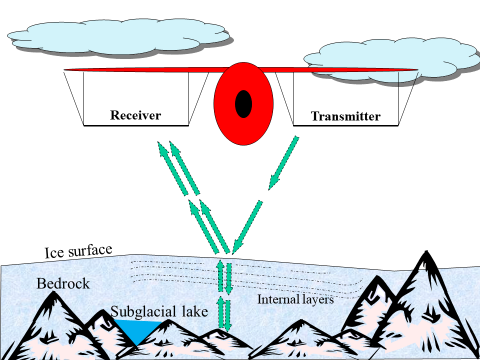
Fig.1: Electromagnetic signal path trasmitted by RADAR
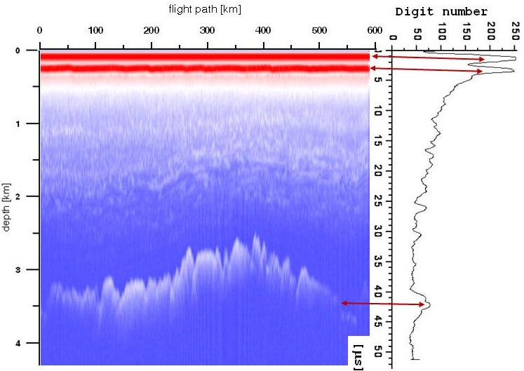
Fig.2: Correlation beetween radar trace (on the rigth) and radargramm (on the left)
RADAR technology applied to glaciology.
The first indication that high-frequency radio signals can penetrate snow and ice was observed at Admiral Byrd's base, Little America (Antarctica) in 1933. Pilots reported that radar altimeters were measuring incorrect values on the ice and the US Army launched an investigation that discovered that ice and snow are transparent to VHF and UHF band electromagnetic radiation (see Fig. 1). Later in 1957, Waite and Schmidt demonstrated that a radar altimeter could be used to measure the thickness of polar glaciers (Waite and Schmidt, 1961). In 1963, the first VHF radar system specifically for radio soundings was developed at the Scott Polar Research Institute (SPRI) at Cambridge University, and various scientific institutions subsequently carried out measurements in the Arctic and Antarctic with this technique that is still in use today.
The first RES survey systems implemented short-pulse envelope radars operating from 30 MHZ to 150 MHz and were used in Greenland and Antarctica. The acquired radar track was displayed on an oscilloscope. The received radar track shown on the right of Fig. 2 is still referred to as the 'O-scope' from 'oscilloscope' while the radargram on the left is a colour map of the track amplitude. The recording system consisted of a 35 mm motorised camera with adjustable film speed, synchronised with the speed of the aircraft. Position determination was initially achieved by the observation of recognisable landmarks by the system operator and later by inertial navigation systems using motion-sensing devices.
Technological improvements have made these RES systems much more powerful. Today, the digital acquisition of radar tracks allows more tracks to be recorded in fast digital mass storage devices, enabling surveys over large areas with better horizontal resolution. Numerical processing of the acquired tracks significantly improves the dynamics and signal-to-noise ratio. In addition, differential GPS measurements make it possible to accurately determine the geographical position of the acquired tracks, reducing uncertainties to ±5 m and ±10 cm in post-processing.