


Select your language

  • IT
  • EN
Italian Radio Echo Sounding
INGV Sezione Roma2
Programma di Ricerche in Antartide
  • Home
    • Photos
  • Measure
    • Measurement technique
    • Ice depth and bedrock elevation
    • Layers measurements
    • Subglacial measurements
    • Crevaces measurements
  • Instrumentation
  • Campaigns
    • Description
    • Antartctic campaigns
    • Italian campaigns
  • Maps
    • Antartic fligths map
    • Italian fligths map
  • Download
    • Files format
    • Antarctic Download
    • Italian Download
  • Projects
    • MACMAP
    • PNRA
  • Publications
  • Staff
  1. You are here:  
  2. Home
  3. Photos
  4. Uncategorised

MAppa dei voli in Italia (working in progress)
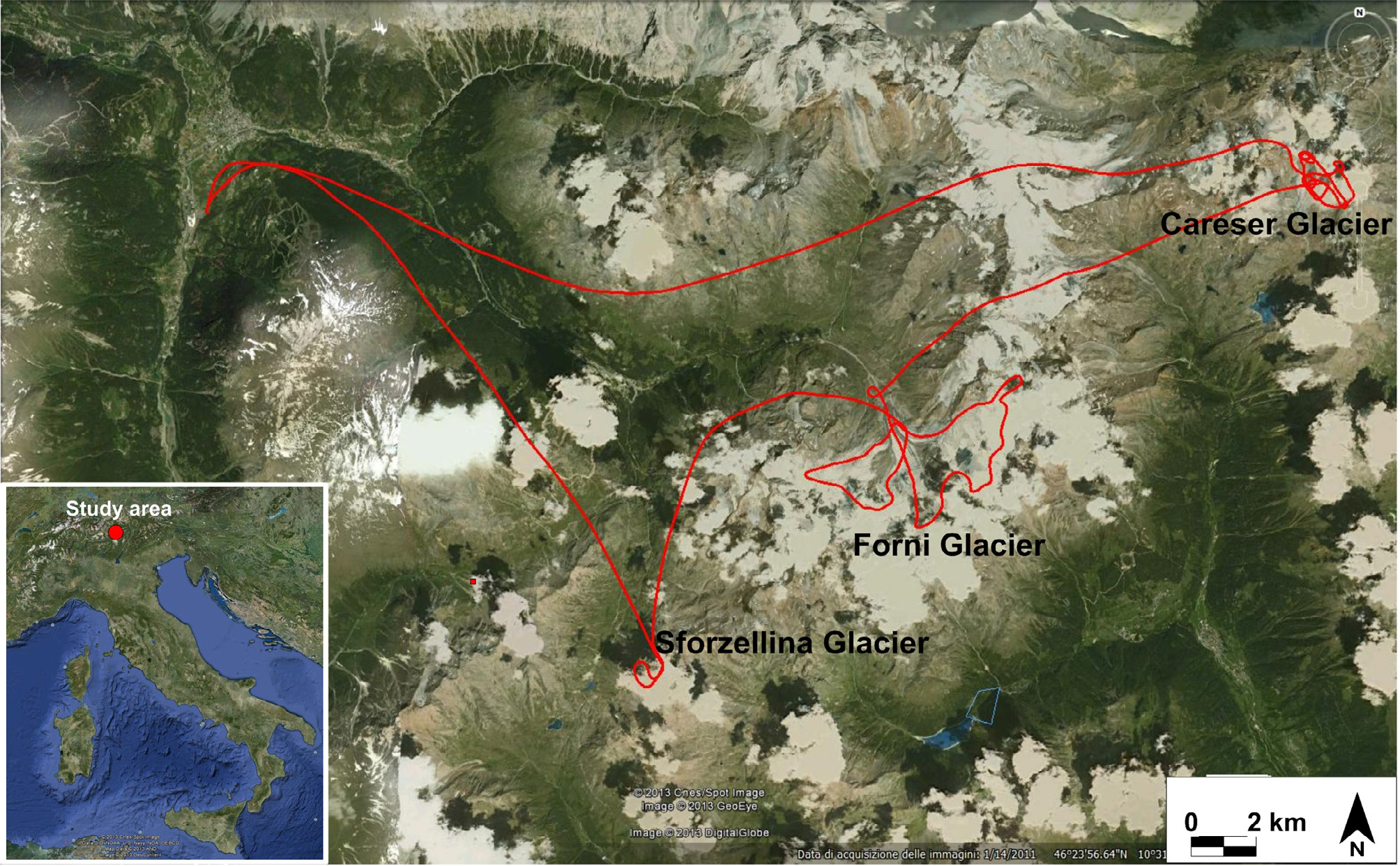
Italian campaign1In the figure the path of the helicopter that allowed the simultaneous overflight of the three glaciers.
In July 2012, our preliminary tests were carried out on a selection of glaciers located in the central Italian Alps:
Careser
Sforzellina
Forni 
The main goal of this first test campaign was to verify the effectiveness of the airborne RES system, trying to collect information on ice thickness and bedrock assessment of the investigated glaciers. 

As part of the National Antarctic Research Project (PNRA), a large number of RES (Radio Echo Sounding) measurements have been acquired on various expeditions to Antarctica. RES measurements with aircraft-mounted instrumentation (airborne RES) were carried out by various nations across the Antarctic continent. The Italian Radioglaciology group, from 1995 to 2003, carried out surveys for over 36,000 km, collecting radar profiles in the eastern sector of the continental glacier in Antarctica, including the coastline and outlet glaciers. These surveys were mainly carried out as part of the EPICA and BEDMAP projects, both of which are relevant to climatological studies. The first project (EPICA) was aimed at extracting a core containing climate data for the last million years.  The RES surveys were aimed at finding the optimal site where ice core drilling could be carried out and study palaeoclimate sequences that were as intact as possible, i.e. free of overlapping stratification due to glacial flow. It was likely that these ideal points would be found in the 'domes' surveys, which was indeed the case, together with preliminary information on ice characteristics and bedrock topography. The second project (BEDMAP 1 and 2) aimed to perform a continental-scale survey to determine the bedrock topography in order to assess the thickness of the Antarctic glacier.

The IRES measurements added to the huge amount of data collected by other international projects to try to quantify the mass balance of the Antarctic ice sheet. Although global data are still lacking, the database available here helps to reduce uncertainty, especially with regard to the East Antarctic Ice Sheet and the Dome C region. Therefore, surveys of the continental ice sheet and major outlet glaciers between the Italian and French bases have been extensively investigated. Data are available on outlet glaciers starting with the David-Drygalski, Campbell, Rennik, Ninnis, and Mertz, which drain to the sea most of the mass lost on the coastline comprising them. In addition, data on the glacier thickness of the region and data for a highly detailed bedrock map of the Dome C area are available in this IRES database.

  Given the large coverage, these two multinational projects reduce the uncertainty of previous estimates and offer new opportunities for detailed modelling of the past and future evolution of the Antarctic ice sheet. In each campaign, research objectives (missions) were defined, linked to the aims or objectives of the research projects funded in those years. The missions, carried out in collaboration with the University of Milan and the INGV in Rome, allowed us to deepen our knowledge of the characteristics and peculiarities of the Antarctic ice sheet and some of its glaciers. Each mission consists of several flights necessary to complete the investigation of a specific area. The entire database has been subdivided in this way for easy searching. The campaigns, missions and flights can be seen in the map on the Antarctic fligths. A list of the research campaigns and investigation areas follows:

  • 1995: Dome Concordia, outlet glaciers of Victoria Land, Ross sea and Frontier Mountains
  • 1997: Progetto Itase, Talos Dome, Frontier Mountain 
  • 1999: Concordia region, Vostok, DC-DDU transect, Rennik, Mertz
  • 2001: Concordia lake, Aurora rift, Talos- Concordia transect, DDU Talos Dome transect   
  • 2003: Wilkes BAsin, Dome C region, Mertz, Itase, Purpoise bay,  Law Muis, Shackleton, West Ice Shelf, Amery

In the tables the fligths and data file  names of the acquired data:

1995 campaign

Miss 01-DC Big grid


Flight 01 - Big flight 01
Flight 02 - Big flight 02
Flight 03 - Big flight 03

Miss 02-DC flight


Flight 01 - Flight star

Miss 03-DC Star


Flight 01 - Ground deep 01
Flight 02 - Ground deep 02
Flight 03 - Ground deep 03
Flight 04 - Ground deep 04
Flight 05 - Ground deep 05
Flight 06 - Ground deep 06
Flight 07 - Ground deep 07

Miss 12 - Victoria Land


Flight 01
Flight 02
Flight 03
Flight 04
Flight 05
Flight 06
Flight 07
Flight 08

Miss 13 - Ross Sea South 95


Flight 01

Miss 14 - Ross Sea North 95


Flight 01
Flight 02
Flight 03

Miss 15 - Frontier Mountains


Flight 01


1997 campaign

Miss 04 - ITASE 98


Flight 01
Flight 02

Miss 16 - Ross Sea South 97


Flight 01

Miss 17 - TD Frontier Mountains


Flight 01
Flight 02


1999 campaign

Miss 05 - Dome C region


Flight 01 - DC1
Flight 02 - DC2
Flight 03 - DC3

Miss 06 - DC Vostok


Flight 01
Flight 02 - VK2
Flight 03 - VK3
Flight 04 - VK4

Miss 07 - Transect DC-DDU


Flight 01

Miss 19 - ITASE01-Rennick-DDU


Flight 01
Flight 02

Miss 20 - TD grid


Flight 01

Miss 21 - Rennick-Mertz-DDU


Flight 01
Flight 02
Flight 03
Flight 04

Miss 22 - DDU-Frost Glacier


Flight 01


2001 campaign

Miss 08 - Lake Concordia


Flight 01

Miss 09 - Aurora Rift


Flight 01
Flight 02 - Rift02

Miss 10 - ITASE01-TNB-TD-DC


Flight 01
Flight 02

Miss 11 - ITASE01-DDU-TD


Flight 01
Flight 02
Flight 03

Miss 18 - Nansen-David


Flight 01
Flight 02


2003 campaign

Miss 24 - Wilkes Basin


Flight 01 - volo02
Flight 02 - volo03
Flight 03 - volo04
Flight 04 - volo05
Flight 05 - volo06
Flight 06 - volo07

Miss 25 - Fossa


Flight 01 - volo08
Flight 02 - volo09
Flight 03 - volo11

Miss 26 - Laghi


Flight 01 - volo10
Flight 02 - volo12
Flight 03 - volo13

Miss 27 - Mertz


Flight 01 - volo14
Flight 02 - volo15

Miss 28 - ITASE


Flight 01 - volo31
Flight 02 - volo32

Miss 29 - Porpoise Bay


Flight 01 - volo17
Flight 02 - volo30

Miss 30 - Law-Muis


Flight 01 - volo18
Flight 02 - volo19
Flight 03 - volo20
Flight 04 - volo21
Flight 05 - volo29

 
The radar Characteristic:
The radar instrumentation used in the various measurement campaigns is continuously changed and updated to obtain the best measurements. The table below shows the characteristics of the instrumentation in the various measurement campaigns. This information is also useful for the interpretation and analysis of the acquired data.


Antarctic Campaign

1995

1997

1999

2001

2003

2009

2011

2012

Freq.operativa  [MHz]

60

60

60

60

60

150

150

150

pti acquisiti x traccia(samp/scan)

512

1024

1280

1280

1280

2048

2048

2048

Intervallo campionamento [ns]

100

50

50

50

50

50

50

50

Versione file BIN

0.0

1.00

2.0

3.0

4.0

5.03

5.03

5.03

Tempo totale [µs]

51.2

51.2

64

64

64

81.9

81.9

81.9

Massima profondità [km]

4.3

4.3

5,3

5,3

5,3

6,8

6,8

6,8

Tracce acq./ s  [tr/s]

0.33

1

10

10

10

20

20

20

Freq acq. punti

10MHz

20MHz

20MHz

20MHz

20MHz

25MHz

25MHz

25MHz

Errore posizionamento [m]

±8.4

±4.2

±4.2

±4.2

±4.2

±3.3

±3.3

±3.3

Pulse length [ns]

1000

1000

1000

1000

1000

1000

200

80-1000

Risoluzione verticale (@1 us general.)

±41.8

±41.8

±41.8

±41.8

±41.8

±41.8

±8.3

±3-±41.8

Receiver Bandwidth [MHz]


Ricevitore

Mc Gordon

Mc Gordon

Mc Gordon

Mc Gordon

Pascall

Ric. INGV

Ric. INGV

Ric. INGV

Acquisition system

TeKtronic Osc.

ISA card Enrico

ISA card Enrico

ISA card Enrico

ISA card Enrico

PDA 14

PDA 14

PDA 14

Antennas

trombone

Wired folded dipole

Wired folded dipole

Wired folded dipole

Wired folded dipole

Rigid folded dipole

Array

1tx

3RX

Array

4tx

4RX

 Amplifier power

ENI

ENI

ENI

Tomco

Tomco

Tomco

Tomco

Tomco

 Peak Power[kW]

2

2

2

4

4

2

2

2

 Amplifier model

 EN4000

EN4000 

EN4000 

BTO4000-AB 

BTO4000-AB 

BT02000

BT02000

BT02000

 type of measurements

a terra

in volo

in volo

in volo

in volo

a terra

a terra

a terra

Fig.1: Ground measurements on sled Greenland 1997.

Fig.2: Ground measurements in Antarctica.

Fig.3: Helicopter measurements: instrumentation.

Fig.4: Helicopter measurements: Bygol-1.

"/

Fig.5: Helicopter measurements: antenna arrangement.

Radar exploration even over large areas is the basis of glaciology and plays different roles in the study of glaciers to determine their thickness and volume, the internal stratification of the ice, the first layers of snow (firn), the topography of the bedrock, including the characterization of crevassed areas. The method, widely used with full success in the polar areas, encounters greater difficulties when applied to the detection of mountain glaciers such as the Alpine and Himalayan ones. These difficulties are due to the different physical characteristics of temperate ice and to the logistical technical problems associated with carrying out field operations at high altitude on areas where there are crevasses, seracs and ice falls, making the glacier surface extremely varied. Depending on the ice conditions, the orography of the areas and its extension, different measurement techniques are used with different means of investigation.

Ground measurements : Ground measurements are used to carry out detailed surveys in areas of particular interest such as drilling sites or small glaciers. The instrumentation is placed inside suitable mechanical means such as snowmobiles (ski-doo) or snow cats (fig. 2), the antennas are mounted on sledges (fig. 1) and towed along the chosen survey paths.

Helicopter measurements : Helicopter measurements are carried out in non-extensive areas and in remote places that are not easily accessible by land or inaccessible means and for this reason they are easily used in the study of Alpine glaciers and in areas coastal areas of Antarctica.

Based on our experience & nbsp; in the realization of RES systems [Tabacco I.E. et al., 1999; Tabacco I.E. et al., 2008 Zirizzotti A. et al., 2008], we developed operating at 40 MHz (4 kW of maximum peak power) with an envelope pulse width varying between 25 ns (1 cycle) and 500 ns ( 20 cycles). 

 The antennas were positioned on a wooden support (Bygol-1) suspended 18 m below the helicopter fuselage by means of a barycentric cable (fig. 4) while the radar electronics occupy a place on the rear seat (fig. .3). In order to facilitate the flight maneuvers of the helicopter, in recent years a fixed mounting of the antenna has been used next to the helicopter trolley through a system of very effective mechanical supports (fig. 5).

Airplane measurements: In Antarctica, where the survey areas are very extensive, aircraft are necessarily used. In the Antarctic expeditions (1997, 1999, 2001 and 2003), the Italian 'Radioglaciology' group used a DE HAVILLAND DHC-6 Twin Otter (TO) aircraft, which was also at the disposal of PNRA with its entire crew for other services in the Italian campaign throughout the entire period of the annual expedition. The TO, although slightly oversized for radar surveys, proved particularly useful as it allows two dipole VHF antennas folded at λ/2 about one metre below the wings to act as reflectors (photo on home page). Being equipped with on-board instrumentation such as laser altimeters and geo-localisation devices, the TO is able to fly at an altitude of 300 m following planned routes. Usually another geo-localisation system, consisting of another GPS satellite receiver, is directly interfaced to the radar track acquisition computer. The pulse repetition rate must be related to the speed (approximately 270 km/h) of the TO and the processing capacity of the acquisition computer.

Drone measurements: With the advent of drones in recent times, we have begun to study the possibility of using them also for RES measurements. In the case of measurements in large areas, the fixed-wing drone seems to be the best solution considering, in addition to the long distances to be traveled, also the weight of the RADAR instrumentation. The fixed-wing dori with internal combustion engine can also travel 1000 km in complete autonomy. ... 


  1. Instrumentation
  2. Crevasse exploration
  3. Subglacial lake esploration
  4. Interglacial layers

Page 2 of 3

  • 1
  • 2
  • 3
Creative Commons License
IRES data by Istituto Nazionale di Geofisica e Vulcanologia are licensed under a Creative Commons Attribution 4.0 International License .
Based on a work at http://ires.ingv.it/.Permissions beyond the scope of this license may be available at Credits & Disclaimer
DOI : https://doi.org/10.13127/IRES
.
SEDE CENTRALE
Via di Vigna Murata 605
00143 Roma
RECAPITI TELEFONICI
+39 06 518601
Fax  +39 065041181
CONTATTI
aoo.roma2@pec.ingv.it
info@ingv.it
CODICE FISCALE
 P.IVA 06838821004